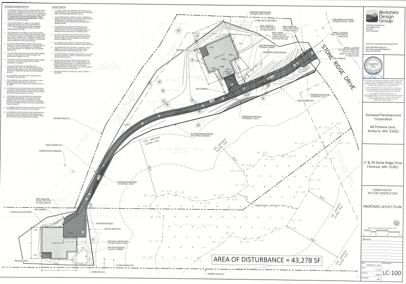
Proposal for two houses on a common drive.
Many may be familiar with the area just east of the switchback end of the Burts Bog Greenway where a bunch of trees were cut a couple of years back, and a few may have noticed a stop work order posted on a tree facing the road.
Thursday April 9 Public Hearings
Conservation Commission agenda online zoom meeting only – see below
Application CC-26-4 follow link and “files” for drawings etc
5:30 PM Notice of Intent for driveway construction in buffer zone. Sunwood Builders. 17 & 39 Stone Ridge Drive. Map IDs 29-609 & 610
Zoom Meeting Link https://us06web.zoom.us/j/85842380900
Meeting ID: 858 4238 0900
Passcode: 239170
Number to access meeting via phone: 1 312 626 6799 Enter the Meeting ID followed by # and then simply press the # key
when asked for a participant ID. To let the host know you have a comment, callers can press *9
7:20 pm Planning Board – application L meeting
Planning. Board agenda in person in the annex behind city hall or on zoom – see below
Application LU-26-11 follow link and “files” for drawings etc
7:20 PM Site plan – shared driveway for two parcels by The Berkshire Design Group, at 17 & 39 Stone Ridge Dr. Map IDs 29-610 & -609.
Site Plan Review: Simple Majority vote required 4 of 7 members. This is a technical permit. The Board must determine that the standards for site plan approval can be met
Applicable Code Sections: 350-8.8R (shared driveway) and 11.6 (Site Plan Criteria)
PUBLIC MEETING LINK (Zoom Meeting ID: 995 8703 7174 Passcode: 128860); or Call 301-715-8592 to access the
teleconference at the scheduled hearing time. Enter the Meeting ID followed by # and then simply press the # key
when asked for a participant ID. To let the host know you have a comment, callers can press *9
Previous History
The Conservation Commission previously considered this project as CC-25-2 at its April 24, 2025 meeting.
Video of that meeting is here and minutes, excerpted below:
“Request for Determination of Applicability to determine if driveway
and house construction is subject to the Wetlands Protection Act or
Northampton Wetlands Ordinance. Shaul Perry/Sunwood Builders. 17 & 39
Stone Ridge Drive. Map ID 29-609 & 610
Shaul Perry stated that Ward Smith conducted a wetland delineation of the site, and silt
fence was installed near the 100 foot buffer zone. The Commission discussed the limit of
work line as shown plan plans; as surveyed the silt fence and tree clearing is within the
100 foot buffer in some locations. Sarah noted that planning board approval will be
required before any additional work can continue; the project includes a common
driveway for which an application has not yet been submitted, and a stop-work order was
issued. Downy suggested that he would be comfortable with staff’s assessment of whether
any mitigation is required once silt fence is pulled back to the 100-foot buffer or beyond.
Allen Bilkin expressed concern about the rest of construction proposed. Kevin noted that
all work will be outside buffer zones and the Commission’s jurisdiction but that planning
board review will be required.
Downey moved to issue a determination by checking positive box 1, to indicate that the
area shown is subject to protection under the Act; 2a to confirm the accuracy of resource
area boundaries, and negative box 4, to indicate that the work is outside resource areas
and buffer zones, and adding a condition that erosion control be shifted to the 100 foot
buffer and that the applicant work with staff on any mitigation that may be necessary for
work done beyond that. Seconded by Paul, the motion carried unanimously by roll call
vote.”
A “staff memo” had been prepared prior to that Conservation Commission meeting:
“Application Overview, Consistency with the WPA and Northampton Wetlands
Ordinance, Staff Recommendations:
Staff visited the site and have no concerns with the accuracy of the resource area delineation; all flags
were present. The stream is intermittent as shown on USGS maps, and verified by staff through
streamstats; with a watershed size of only .06 square miles, far less than the half square mile drainage
area minimum. Planning Board site plan approval will be required since a common driveway is
proposed; the work is currently under a stop-work order.
The area noted as ‘proposed driveway’ has been cleared and graded, and trees removed. There is a silt
fence installed. The location appeared approximate to that shown on plans, but it was not possible to
field verify whether the ‘proposed silt fence / limit of work’ shown on the plan matches the location as
installed. The majority of work is outside the 100’ buffer zone and outside jurisdiction, but there are
areas (upgradient of flags A34-37) where the work limit is within the buffer zone, and trees have been
removed in this area. If the trees were within buffer area, the Commission could require that they be
replaced. The limit of work should be shifted to the 100’ boundary or beyond, and an updated plan
submitted. The applicant should be clear that no additional work within buffer zones will be allowed
without additional review. If the above issues can be addressed, a determination could be issued by
checking positive box 1, to indicate that the area shown is subject to protection under the Act; 2a to
confirm the accuracy of resource area boundaries, and negative box 4, to indicate that the work is
outside resource areas and buffer zones.“